Software for creation of custom GPS maps compatible with Garmin GPS units
Mapwel is software for creation of GPS maps. Supports automotive, PDA and handheld Garmin GPS units. Creation of map for GPS involves drawing of map, conversion of data into GPS native format and upload of data into GPS. Mapwel is the only available software that allows user to do above three steps with a single software tool.
Mapwel allows to draw map with use of straight lines and curves. When drawn with curves, map can be uploaded into the GPS with chosen precision/data-size ratio. Thus, you can not only draw maps faster but also accommodate the same map for various GPS units with different memory size.
Mapwel provides powerful and easy-to-use drawing tools for creation of areas, lines and other map elements. Object Inspector window displays information about map objects and simplifies the object manipulations. Map can be calibrated (synchronized) with use of the known coordinates of two spots on the map.
For your convenience, Mapwel allows you to draw the map in any colors you choose and the 'What you see is what you get' interface (WYSIWYG) shows you how the map will look like on the color or monochrome GPS display. Mapwel also simulates the Nighttime and Marine color modes.
Map can be drawn from the scanned paper chart, aerial photos and/or with use of tracks and waypoints imported from your GPS. Tracks and waypoints are automatically converted into the map elements.
User can apply Contrast, Brightness and Gamma filters to the scanned chart or photo to adjust the background for convenient drawing of vector objects on the top. Semi transparent area fills allow to draw objects on top without hiding the area beneath.
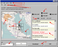
Mapwel allows user to draw map in any colors. It is useful for drawing of large maps or maps with number of land contours, for example. User can assign different color to objects of the same type. However, map transferred into GPS does not contain color data. GPS assigns colors to objects according to their type. When drawing the map, use display mode tabs (3) in the left bottom corner of the Mapwel screen to review your map in the real GPS colors.
Use Mapwel WYSIWYG workspace to create complete GPS map with filled areas, all types of lines, map features, cities, exits and points of interest with adresses. Do not limit yourself to just tracks and waypoints. Use Mapwel import capabilities to open existing maps in various formats (ESRI shape files, for example).
When converting to GPS native format, Mapwel automatically splits large objects to meet GPS technical requirements and does lot of other automation to make creation of map as easy as possible.
Upload your map directly into the GPS. Mapwel allows you to add your map to other maps already present in GPS memory. With Advanced version you can even export map into GPS native IMG file format or into widely used MP format.
Requirements:
• screen resolution 1024x800
• True Color display
• 2 gigabyte RAM
Operating system:Windows All

Database management software that helps you to organize your school/teacher data.
Price: $75.00, Rating: 5, Downloads: 177
Download

OkMap is a free software for many outdoor activities: Trekking, Off road, Mountain bike, Sailing, Hunting and fishing, Finding mushrooms, Soft air, Geocaching, And many others...
Price: $14.50, Rating: 10, Downloads: 113
Download

The program converts text to speech. All computer voices installed on your system are available to Balabolka. The program allows you to convert text into a WAV, MP3, OGG or WMA audio file so you can listen later.
Price: $0, Rating: 5.5, Downloads: 105
Download

With Photo Lottery Director you can create and manage your own photo lottery. A lottery contains up to 99 scenes with certain sequence, one or more winners can be drawn in each scene.
Price: $49.95, Rating: 5, Downloads: 98
Download

Save money by always having your car costs under control with this program: Fast and simple collection of all expenditure for your car/motorbike. Collect your insurance costs, car tax, repair costs and also your fuel costs. With many tips.
Price: $19.95, Rating: 8, Downloads: 89
Download